Bali, Indonesia

Cascading emerald tiers carve into the hillside at Tegallalang, where the ancient subak irrigation system turns every slope into a living, rippling mosaic of green. This watercolor study of the Tegallalang Rice Terraces in Bali captures their lush, layered depths in warm jade and soft rose morning light.
Original Series / Visual Study
Regional Dossier

BALI, INDONESIA | "Pulau Dewata, Island of the Gods"

Bali is the most spiritually alive island in the world, a 5,780 square kilometer Hindu enclave within the world's largest Muslim-majority country, where the Balinese Hindu religion permeates every aspect of daily life from the small palm leaf offerings (canang sari) placed on every threshold every morning to the cremation ceremonies, temple festivals, and rice paddy rituals that structure the calendar around a cosmological framework that has remained essentially unchanged for a thousand years. The island's extraordinary landscape, the volcanic peak of Gunung Agung (3,142 m) rising above the terraced rice paddies of Tegalalang and Jatiluwih (a UNESCO Cultural Landscape), the black sand beaches of Lovina, and the coral reefs of Amed, is inseparable from the spiritual geography that the Balinese overlay on every natural feature.

The colors are the specific palette of tropical spirituality: the deep gold of the temple umbrellas (tedung) clustered at a cremation ceremony, the brilliant green of the rice paddies in the morning light before the Balinese day reaches its full heat, the deep grey of the volcanic sand beaches at Candidasa, and the extraordinary warm orange of the sunset over the Indian Ocean at Tanah Lot when the sea temple silhouette and the sky above it become the most photographed composition on the island.

Select Size
Museum-Grade Canvas
Ready to Hang
Made to Order · Ships in 3–5 Days (U.S.)
Add to the collection for /

$65.00

Finding the Stillness

It's hard to put the "vibe" of a place into words, so we put together a few images that we think show the quiet side of Bali, Indonesia. These are the textures and small moments we've archived to capture the stillness of this corner of the world.

Bali, Indonesia visual study 01
Bali, Indonesia / No. 01 via Max Kukurudziak
The silhouette of towering palm trees against a vibrant gradient of violet and amber captures that fleeting, magical moment where the day exhales into a quiet, tropical night. It’s a gentle reminder of the world’s natural rhythm, offering a sense of profound stillness and the promise of a fresh perspective with the rising sun.
Bali, Indonesia visual study 02
Bali, Indonesia / No. 02 via Ahmed Imran
The lush, emerald tiers of these rice terraces reveal the incredible harmony between nature and human ingenuity, carved beautifully into the rolling landscape. Bathed in soft, golden light, the scenery evokes a deep sense of calm and a renewed appreciation for the steady, patient growth found in the natural world.
Bali, Indonesia visual study 03
Bali, Indonesia / No. 03 via Andrey Bond
The multi-tiered thatched roofs of these sacred temples rise toward the sky, embodying a centuries-old tradition of devotion and architectural grace. Nestled against a backdrop of mist-covered forests, the scene invites a moment of quiet reflection on the enduring beauty of cultural heritage and spiritual peace.

Where to wander

Archival Note: A curated field study of Bali, Indonesia, prioritizing cultural relevance and archival merit. These locations have been meticulously researched and vetted to ensure they represent the most authentic atmosphere for your own expedition.

Local Cuisine Spotlight
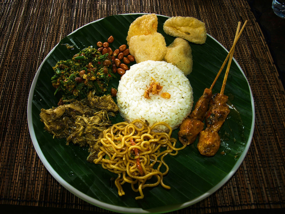
A bowl of Cao Lau offers a vibrant taste of Hoi An’s rich history, where every fresh herb and perfectly seasoned shrimp tells a story of cultural harmony. Sitting down to a meal like this is a soulful experience, inviting you to slow down and savor the authentic, nourishing flavors that have brought people together for generations.
Credits: LUDO POIRÉ
Local cuisine study in Bali, Indonesia

☕︎ Local Flavor

Ubud Organic Farm Cooking Class

Rating: 4.9★ | Price: $$ | Coordinates: 8.4717° S, 115.2811° E

Navigate the terrace-fringed peripheries of Ubud to source indigenous galangal and turmeric from volcanic soil. This curriculum prioritizes the Base Gede spice paste, a fundamental aromatic sequence that dictates the rhythm of Balinese life. It serves as a vital sensory archive, preserving the lineage of agrarian survival and communal culinary identity.

View Entry Details

Pasar Badung Market Heritage Walk

Rating: 4.7★ | Price: $ | Coordinates: 8.6591° S, 115.2136° E

Unearth the kinetic energy of Denpasar's primary artery, where the scent of incense mingles with sea salt and tropical flora. The architecture of the market functions as a living museum of local trade, featuring reinforced concrete structures that house centuries-old barter traditions. Documenting this site is essential for understanding the urban metabolism and the economic anchor of the island’s capital.

View Entry Details

Traditional Babi Guling Preparation at Ibu Oka

Rating: 4.5★ | Price: $$ | Coordinates: 8.5069° S, 115.2625° E

Discover the precise geometry of slow-roasting, a ceremonial process involving local timber and hand-turned spits. The dish utilizes a complex interplay of lemongrass, coriander, and black pepper, creating a physical sensation of heat and depth. It remains an indispensable piece of the cultural puzzle, documenting the specific festive rituals that define Balinese Hinduism.

View Entry Details

Seminyak Market & Culinary Circuit

Rating: 4.8★ | Price: $$ | Coordinates: 8.6823° S, 115.1633° E

Stroll through the coastal morning markets to witness the arrival of the daily catch and the sorting of ceremonial offerings. The market operates as a physical manuscript of the island's coastal adaptation, blending traditional ingredients with the demands of a globalized palate. It stands as an anchor for the city's modern identity, preserving ancestral tastes amidst rapid modernization.

View Entry Details

🛌︎ Boutique Stays

The Pavilions Bali

Rating: 8.8★ | Price: $$$ | Coordinates: 8.6946° S, 115.2594° E

Ascend into a private sanctuary modeled after a traditional Balinese village, where walled gardens provide a silent respite from the Sanur coast. The villas feature hand-carved Indonesian hardwoods and local stone, reflecting a meticulous commitment to vernacular architecture. This stay is a physical archive of the "home compound" philosophy, preserving the spatial intimacy of Balinese domestic life.

View Entry Details

Segara Village Hotel

Rating: 8.8★ | Price: $$$ | Coordinates: 8.6734° S, 115.2631° E

Navigate the sprawling grounds of this iconic establishment, which mirrors the layout of a traditional banjar community. The structures utilize red brick and thatch, architectural choices that echo the historical coastal settlements of the 1950s. It functions as an anchor for the city's tourism lineage, documenting the evolution of hospitality on the island.

View Entry Details

Kejora Suites

Rating: 9.0★ | Price: $$$ | Coordinates: 8.6917° S, 115.2638° E

Discover a boutique retreat where contemporary glass meets the weathered textures of tropical timber. The design prioritizes the flow of air and light, grounding the guest in the physical sensations of the coastal climate. This site serves as a vital piece of the architectural puzzle, documenting the transition into modern Indonesian luxury.

View Entry Details

Mahagiri Villas Sanur

Rating: 9.0★ | Price: $$$$ | Coordinates: 8.7001° S, 115.2589° E

Unearth the quiet grandeur of villa living, where private pools are framed by meticulously curated tropical flora. The architecture employs heavy basalt and smoothed plaster, creating a sense of permanence and weight. It acts as a physical manuscript of the island's high-end development, preserving a sense of Zen-inspired tranquility.

View Entry Details

📍︎ Field Study

Besakih "Mother Temple" Architectural Study

Rating: 4.8★ | Price: $$ | Coordinates: 8.3740° S, 115.4510° E

Ascend the six terraced levels of the largest temple complex in Bali, situated on the southwest slopes of Mount Agung. The site features 23 separate but related temples, characterized by multi-tiered meru shrines that represent the cosmic mountain. It is a physical manuscript of Balinese spiritual endurance, having miraculously survived the 1963 volcanic eruption.

View Entry Details

Tirta Empul Holy Water Temple

Rating: 4.7★ | Price: $ | Coordinates: 8.4153° S, 115.2894° E

Discover the rhythmic flow of the 30 stone spouts where sacred spring water has emerged since 962 AD. The temple's basalt masonry and rectangular purification pools demonstrate a sophisticated understanding of hydro-engineering and spiritual geometry. This site is a vital anchor for the island's identity, documenting the lineage of the Melukat ritual.

View Entry Details

Ubud Royal Palace (Puri Saren Agung)

Rating: 4.6★ | Price: $ | Coordinates: 8.5067° S, 115.2626° E

Navigate the intricate brick gateways and gold-leaf carvings of the official residence of the Ubud royal family. The architecture is a masterclass in the Kosala-Kosali design philosophy, which aligns the human environment with the divine. It serves as a cultural repository, preserving the artistic patronage that established Ubud as a global creative hub.

View Entry Details

Jatiluwih Rice Terraces Trek

Rating: 4.9★ | Price: $$ | Coordinates: 8.3693° S, 115.1311° E

Unearth the ancient Subak irrigation system, a UNESCO-recognized social and technical manuscript of the land. The landscape is a living sculpture of contoured earth and flowing water, physically documenting a millennium of agricultural cooperation. It is a vital piece of the puzzle, preserving the sustainable lineage of Bali's agrarian heart.

View Entry Details

Typography

Archival Note: A formal technical study of Bali, Indonesia, archiving the coordinates, elevation, and environmental data that define the region. This data serves as a vital record for our ongoing global field study, providing the technical foundation behind every atmospheric detail captured in our visual work.

Botanical and pigment specimen study for Bali, Indonesia Colors of Bali, Indonesia
Coordinates
8.4095° S, 115.1889° E — Lesser Sunda Islands, Indonesia
Historical Epoch
Majapahit Hindu Empire influence established Balinese Hindu culture in the 13th–15th centuries. Dutch colonial conquest and the Balinese royal puputan mass suicides rather than submission in 1906–1908. UNESCO Cultural Landscape inscription for the subak irrigation system in 2012.
Elevation
0–3,031 m / 0–9,944 ft, coastal beaches to the peak of Mount Agung
Atmosphere
Tropical Rainforest (Af). Dry season April through October is the travel window, 26–30°C with low humidity. Wet season November through March brings daily afternoon thunderstorms with morning mist in the highland terraces.
Observation Hour
06:15. First light turns the Tegallalang and Jatiluwih rice terraces to liquid green and amber, the low morning angle backlights the palm fronds and illuminates the terrace walls from the ridge roads above Ubud.
Primary Pigment
Marigold Gold (#FFD700) and Deep Pura Slate (#4A4A4A)
Best Time to Visit
April through October, the dry season keeps the rice terraces brilliantly green, the temple ceremonies are most accessible, and the surf is consistent on the south coast
Avoid Visiting
January through March, the northwest monsoon brings heavy rain to Ubud and Canggu, the surf switches to the north coast, and the roads flood regularly

Behind The Scenes

Nathan

Note from the Founder

Hey, did you know this fun fact about Bali, Indonesia? Bali is home to a unique UNESCO-protected irrigation system called Subak that has allowed local farmers to grow rice on stunning terraced hillsides for over a thousand years.
Thank you for exploring the Bali, Indonesia series with us. We hope these notes have inspired you to add this incredible destination to your own passport—we are so glad you're here. — Nathan

Some of our Favorites